Oedelem-Zomergem Cuesta

The cuesta (Spanish for "slope") of Oedelem-Zomergem is a regionally prominent, hilly area in the northwest of the province of Oost-Vlaanderen. The main residential centers in and around the geosite are Kleit, Oostwinkel, Oedelem, Zomergem, Ursel, Knesselare and Oostveld. The geosite is intersected by the N44 and Ursel airport. The cuesta is mainly drained by the Ede River. Therefore, the top of the cuesta front forms a watershed line, with streams on the cuesta front draining southward toward the Beernem depression, while streams, such as the Ede and the Flabbaert Brook, drain from the cuesta ridge northward toward the coastal plain.

51.151024006195, 3.47324635

Schematic map representation of the shallow and deep sea at the time of the deposition of the cuesta sediments.

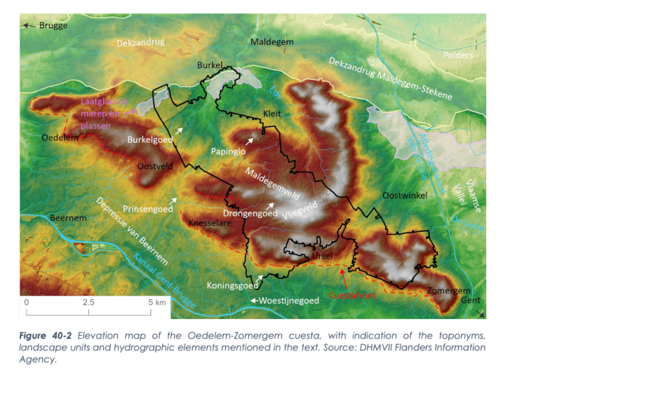
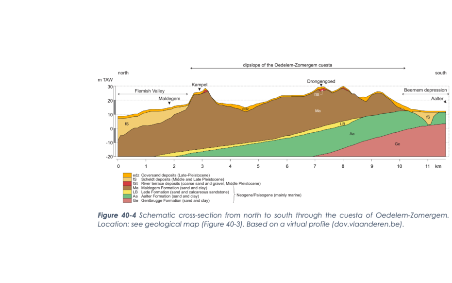
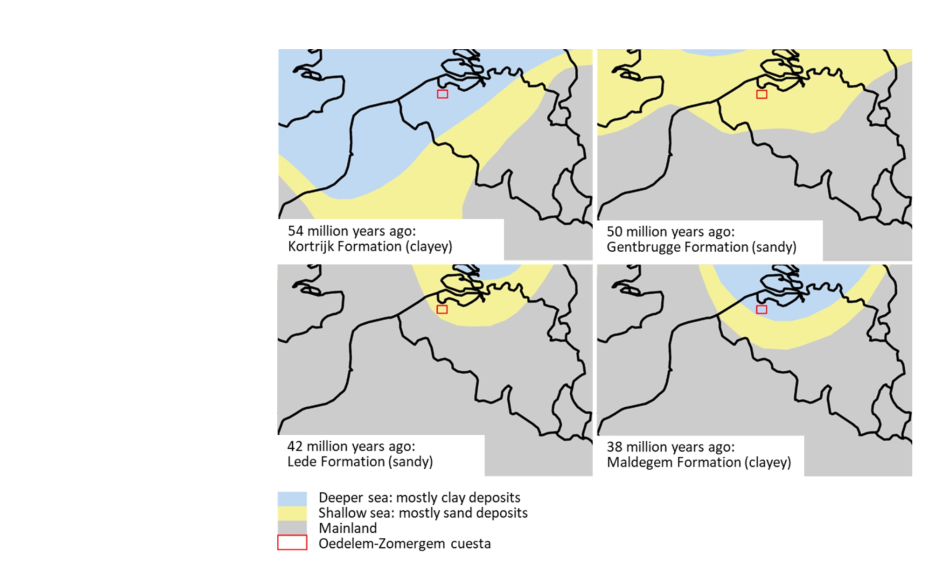
Formation of a cuesta

A cuesta is an asymmetrical ridge and occurs when geologic layers become sloping and then, due to their different composition, do not erode at the same rate. The sloping layer that erodes at a slower rate remains partly as an elevation in the landscape. Where this softer layer is eroded, a steep slope forms perpendicular to the hard layer: the cuesta front. Parallel to the sloping, erosion-resistant layer, a softer slope forms: the cuesta ridge.

Hoogtekaart

Varying depositional environment

The deposition of cuestase sediments started during the Eocene, When the Netherlands and northern Belgium were below sea level and the sea deposited clay. Coarser sediment particles ended up mostly near the coasts. Finer particles settled in the deeper parts of the basin. Due to climate changes, sea levels fluctuated during this period. However, mainly the glauconitic, sandy Formation of Aalter and the glauconitic, clayey Formation of Maldegem are important for the formation of the cuesta of Oedelem-Zomergem. The core of the cuesta consists mainly of sediments of the Maldegem Formation. This geological unit is up to 40-50 m thick and formed between 42 and 38 million years ago mainly from clay layers.

Schematic cross-section from north to south through the cuesta of Oedelem-Zomergem

Slope setting Eocene layers

While sedimentation occurred in the North Sea basin, plate tectonics in southern Europe caused the formation of several mountain ranges. Because of this uplift in the south, the Earth's crust descended in the north and already deposited sediments tilted in a northeastward slope As a result, the geosite evolved from submarine to terrestrial at the end of the Eocene. To the (north) east of the geosite, Oligocene marine clay layers were deposited on top of these sediments. These diurnals are not present (anymore) on the cuesta of Oedelem-Zomergem. During the ice ages of the Pleistocene, the sea level was much lower. This created stream and river valleys. Here, loose sand was more easily carried away than hard sandstone banks or clay layers and formed the cuesta front. However, the compact, clayey Maldegem Formation eroded more slowly and formed the cuesta ridge. At the end of the Weichsel pleniglacial, loamy sand was blown from the north(west) over the slopes of the cuesta ridge. Sand did not blow very far and swirled down around the base of the cuestarug.

Maldegemveld, Drongengoedbos (gemaakt door Toerisme Oost-Vlaanderen)

Formation of cultural landscape

The cuesta ridge was not very productive with ancient arable techniques due to its thin and acidic (clayey) sandy soil, shallow clay layer and -groundwater table. As a result, the hill was mainly used extensively for cattle grazing or deforested for timber. This also forms the origin of "field" soils, such as the Maldegem field. Semi-open heathland landscapes with small groves or brushwood and fens. These wet depressions formed where little sand was blown up and the underlying clay was near surface. Since the cuesta was not very fertile but still offered opportunities, a certain cycle is recognizable in the history of its land use. At times of population pressure and stress on the landscape, the cuesta was used more intensively, possibly out of necessity, despite its apparent unattractiveness. When the pressure decreased, so did the intensity of clearing.

Visit via: Krakeelparking, Drongengoedweg, 9910 Maldegem, Belgium