Western Scheldt

The Western Scheldt is the Dutch part of the estuary of the river Scheldt, which rises in northern France and flows through Belgium into the Netherlands. The entire Scheldt estuary (the part of the river under tidal influence) extends from the mouth at Flushing to Ghent, where weirs and locks stop the tidal flow. The part of the Scheldt estuary on Belgian territory is also called "Zeeschelde". With an area of about 35,000 ha, the Scheldt estuary is one of the largest estuaries in Europe, and with its 160 km length from Vlissingen to Ghent, it is also one of the longest estuaries in Europe. The mixing of salt seawater with fresh river water means that in the Scheldt estuary there is a complete gradient from salt over brackish to completely fresh. The estuary is a very dynamic area consisting of tidal channels of varying depth and tidal flats, mud flats and salt marshes.

51.418045969794, 3.6665909119141

The location of the successive mouths of the Scheldt in Zeeland after the last ice age, with their period of greatest activity

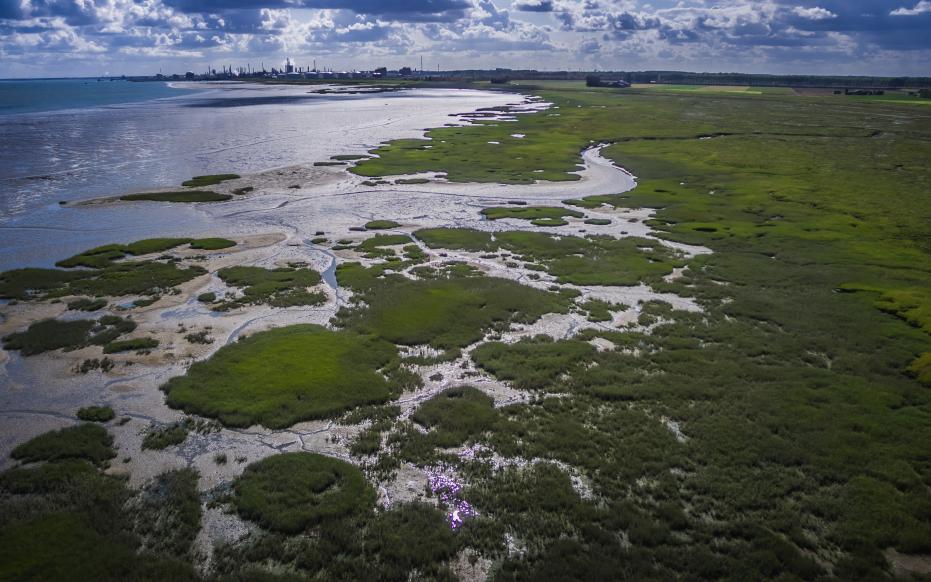
Ontstaan van het landschap

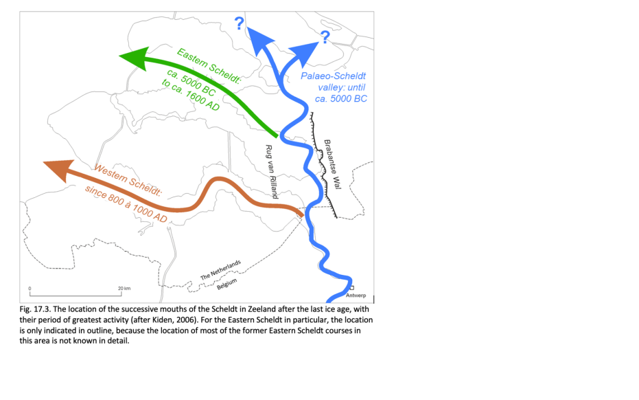
Geologically speaking, the Western Scheldt formed the estuary of the Scheldt only very recently.  About 7000 years ago, a tidal channel made contact with the Scheldt approximately at the site of today's Eastern Scheldt and thus became the new course of the Scheldt to the sea.

Around 3800 years ago, an almost continuous beach ridge had formed approximately at the site of the present coastline. A narrow opening at the site of today's Eastern Scheldt formed the mouth of the Scheldt. Breakthroughs also occurred at the site of today's Western Scheldt estuary and tidal channels penetrated deeper and deeper into the land. Exactly when the Western Scheldt was formed is not known, because historical sources and maps from that period are scarce, and because deposits from the early phase of the development of the Western Scheldt have all been cleared away by the widening and deepening of the estuary. The only thing that can be deduced with certainty from historical sources is that the Western Scheldt already existed in 1183 AD.

Paulinaschor - schorgebied grenzend aan de Paulinapolder (gemaakt door Arjen Hartog)

Mudflats, salt marshes, slabs and channels

In many places along the Western Scheldt, a number of characteristic estuary landscape elements can be seen from the dikes at low tide. The so-called salt marshes (or salt marsh) are closest to the dike and are largely overgrown. Further away from the dike are the mudflats, which are flooded and uncultivated at every tide. Flats also lie between high and low tides, but are not attached to the shore and are in the middle of the wide estuary. Most of the flats are uncultivated and, because of their sandy bottoms, are more reminiscent of a beach, in contrast to the silty and "muddy" mudflats. Exceptionally, some parts of slabs are so highly silted that they no longer flood daily, becoming overgrown and forming salt marshes. This is the case with the "Hooge Platen", the Ossenisse plates and the Walsoorden plate. Between the tidal flats and the banks of the Western Scheldt are large and deep tidal channels used as shipping lanes for sea vessels calling at the ports of Antwerp, Terneuzen, and Ghent. Locally, such deep channels cut ancient deposits of Paleogene, Neogene and Pleistocene age, from which they absorb fossils deposited on the banks of the Western Scheldt.

De Kaloot - strand en duingebied met aanspoelende fossielen (gemaakt door Arjen Hartog)

Ebb and flow salt marshes

In the Western Scheldt, two or more tidal channels are usually present side by side. The channel followed by the ebb current is the deepest and meanders in curves from one bank to the other. Because of its depth, this ebb tidal channel is also the main shipping route along which large ocean-going vessels reach the ports. Continuous maintenance dredging is required to keep these shallower sills at depth for shipping. Next to the ebb tidal channel are usually straighter, shallower channels that are used primarily by the tidal current and are separated from the ebb tidal channel by shallows and flats. The tidal channels in the Western Scheldt exhibit a pattern of ebb and flood shears typical of many estuaries.

Zeehonden op de Platen van Ossenisse in de Westerschelde (gemaakt door Annelien Bij de Vaate)

The workings of an estuary

At an average high tide, about 1 billion cubic meters of seawater flows into the estuary at Flushing. The amount of water flowing in and out of the estuary depends on the bowl storage. Changes in bowl storage due to natural or human causes have large-scale and sometimes irreversible consequences for the development of the estuary. The bowl storage increases when, for example, dike breaches cause flooding of polder areas that were previously outside the estuary. This causes more water to flow into the estuary, increasing the size of the tidal channels. Conversely, a reduction of the tidal marsh storage capacity, e.g. by embankment or reclamation of mudflats and salt marshes, causes tidal currents to diminish and channels to silt up.

Blootgespoeld middeleeuws landschap Oud-Rilland, Schor van Rilland in de Westerschelde (gemaakt door Anita Eijlers)

Human influence

In addition to the natural factors mentioned above, the embankments and reclamations since the 12th century have played a part in the development of the Western Scheldt estuary. It became narrower and deeper, which pushed up the tides and greatly increased the tidal range and flood levels. Also, the tides penetrated further and further into the estuary. Since the early 20th century, the channel between Flushing and Antwerp has been dredged deeper and deeper, causing the tides to penetrate even further into the estuary. As a result, high water levels are becoming even higher, especially upstream of the Belgian-Dutch border, and the danger of flooding is increasing. To increase flood safety during storm surges, areas are reclaimed and controlled flood plains are created.

Visit via: Westerhavenweg 2a, 4382 NM Vlissingen, Netherlands