Zwin

The 'Zwin' geosite is located on the eastern border of the Belgian coastal plain. The national border lies in the active sea channel and it is therefore a cross-border geosite. The contemporary nature reserve The Zwin extends from the beach and coastal dunes to an active tidal landscape with mud flats and salt marshes. In addition, several historic polders also lie within the geosite. Part of a the Willem-Leopold Polder was recently partially re-poldered and now lies within the nature reserve. Finally, the site also contains traces of historical border conflicts, including Fort Isabella and the Cantelmolinie. The origin of the Zwin can be traced back to the Sincfal, a tidal channel in the Roman period and early Middle Ages, and possibly even to a Middle Holocene channel at the level of today's Scheur, the shipping channel off the coast of Zeebrugge. The exact age of the Zwin can no longer be determined because the oldest sediments have been eroded by storms and tides.

51.358319644726, 3.3495119441803

7  Schematic map of the Zwin region about 7500 years ago.

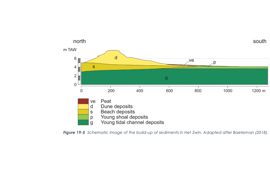
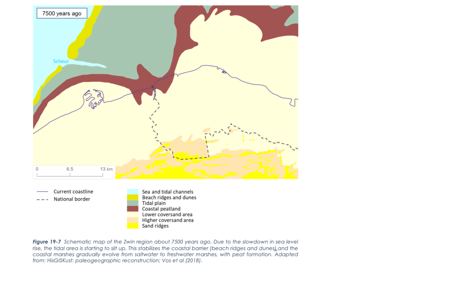
Sea level rise, mudflats, and peat bogs

Rising sea levels did not gain influence in the Zwin Region until 7000 to 6000 years ago. The coastal belt was then 10-15 km off the present coast but stabilized and even shifted slightly seaward until 5500 years ago due to delayed sea level rise and supply of eroded sediment. Along higher edges, a peat swamp formed over the Pleistocene sandy landscape as fresh groundwater bubbled up. Until 2,800 years ago, the coastline remained stable and the peat swamp was able to expand further and further inland over the cover sand area and (locally) over the silted up salt marsh in parallel with slower sea level rise.

Schematic image of the build-up of sediments in Het Zwin

Open coastal landscape with gullies

Starting 2800 years ago, climate change and inland deforestation caused increased drainage in the peatlands. As a result, gullies began to cut in and increased tidal space behind the coastal belt. This incision created an open tidal channel landscape with "islands" of older salt marsh and peatlands. The dune belt and cover sand ridges along the edges of the area formed part of a coastal defense line during Roman times. From the settlements, the landscape was drained for small-scale agriculture or peat extraction, and raised roads were established as protection against flooding. In the early Middle Ages, settlements arose in a similar way on mounds located on the salt marsh and along the channels. From these settlements, ring dikes were constructed to protect the nearby area and to intensify reclamation. This created the first polders.

Natuurreservaat Het Zwin (gemaakt door Marcelle Davidse)

Sincfal

With the silting up of the Blankenberge channel and (later) the Oostkerkegeul channel, at least one channel (partly in a creek) was constructed between the Sincfal and (early) medieval Bruges: the Oud Zwin This, however, unintentionally also reinforced the silting up of the outer dike area, including the channel connection between Bruges and the Sincfal.

Bloemen in bloei in Het Zwin

The Zwin

In 1134 AD, a strong storm surge scoured an old estuary of the Sincfal again. Thanks in part to the Zwin, Bruges grew into an international port city. The natural silting up of the salt marsh along the Zwin and the later reclamation caused accelerated natural silting up, making it increasingly difficult for ships to reach Bruges. The reduced navigability of the Zwin channel reinforced the development of outer harbors. A new coastal belt with dunes formed over the already silted up part of the Zwin estuary between Knokke and the present Zwin reserve. The final coastline and youngest active dunes for the Zwin formed only after the Zwin channel was almost completely closed. During the Eighty Years' War and the War of the Spanish Succession, the Zwin estuary was part of the front line and lines of forts and earth walls were built on both banks at the level of the later land border. Flooding was also a war tactic. During WWI and WWII, the Zwin again received a military function in the Hollandstellung and Atlantikwall, respectively. The tidal area even expanded again recently with the de-poldering of the Willem-Leopold Polder, to slow down the natural silting and siltation.

Visit via: Graaf Léon Lippensdreef 8, B-8300 Knokke-Heist, Belgium