Coversand area Sint Jansteen

The geosite is located on the transition zone of a high sandy landscape formed during the last ice age and a lower creek area. The area with a total area of about 50 km2 extends between Zelzate in the west and Hulst in the east and contains several west-southwest-east-northeast oriented cover sand ridges.

51.255731878055, 4.0486124

Geological map of the geosite and adjacent areas

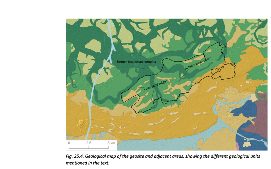
Origin of the landscape

During the last ice age, the landscape consisted of a polar desert with little vegetation and higher cover sand ridges. After the ice age, the sea level rose and drowned part of the lower cover sand landscape which changed Zeeland into a tidal area with peat bogs on the edges. In Zeeuws-Vlaanderen, only the high-lying cover sand ridges remained above the peat. The protective coastal barrier was gradually broken again in the Late Iron Age, causing parts of the peat landscape to be influenced by the sea again. In the 13th century, a tidal system formed here, dividing Zeeuws-Vlaanderen into two areas for centuries. From the large tidal channels, creeks were eventually able to work their way far inland through the peaty area of the geosite, along and sometimes right through the higher thought sand ridges. The cover sand ridges formed the areas where medieval settlement was concentrated. From these villages, the peat in the geosite area was eventually excavated in the Middle Ages and transported to cities such as Ghent via inland peat canals such as the Zoute Vaart.

Op de grens van Stropersbos en Waterleidingbos (gemaakt door Walter Jonkers)

Creeklopen

It is also easy to see how the 16th-century southern bank of the Braakman itself ran. In fact, it is characterized by a line of Spanish fortifications, the remnants of which still lie as elevations in the landscape today. The fortifications were built in the 16th century along the Braakman's salt marshes to repel the incursions of State troops from the Axel region. Persistent tidal action allowed creeks to breach even parts of the cover sand ridges. Some creeks running through the geosite have an unnatural rectangular pattern. This is because these creeks formed while the low-lying peatlands were already being drained by a network of ditches and sluices. The creeks managed to tap some ditches during their formation, gradually widened and scoured deeper. The southeast - northwest orientation of the cover sand ridges is determined by the dominant wind direction. At the level of the geosite, the cover sand ridges are largely still on the surface, but also in the rest of Zeeland such ridges must once have dominated the landscape. Nowadays, however, they are buried under meters thick packages of clay and peat.

Visit via: Van Hogendorplaan 2, 3752 GR Bunschoten-Spakenburg, Netherlands